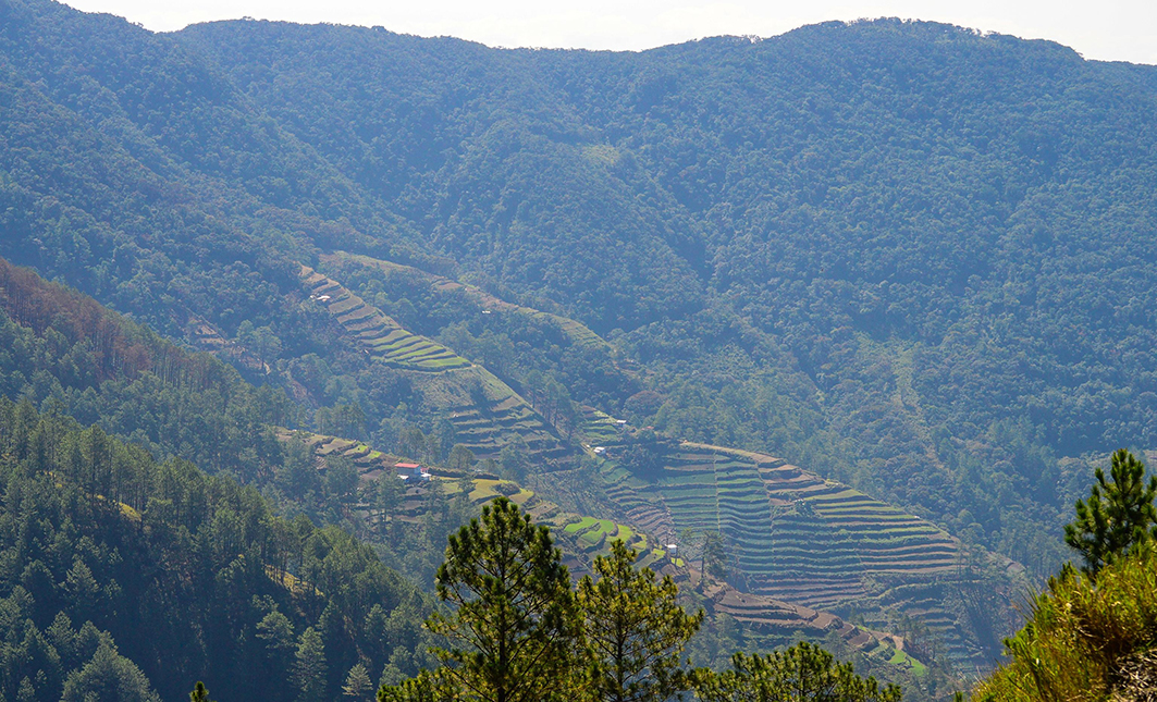
AS early as in Grade 1, *Manuel, 62, recalls how their father had already taught him and his two brothers all the farm work they needed to make their two-hectare vegetable farm inside the Mt. Pulag National Park productive.
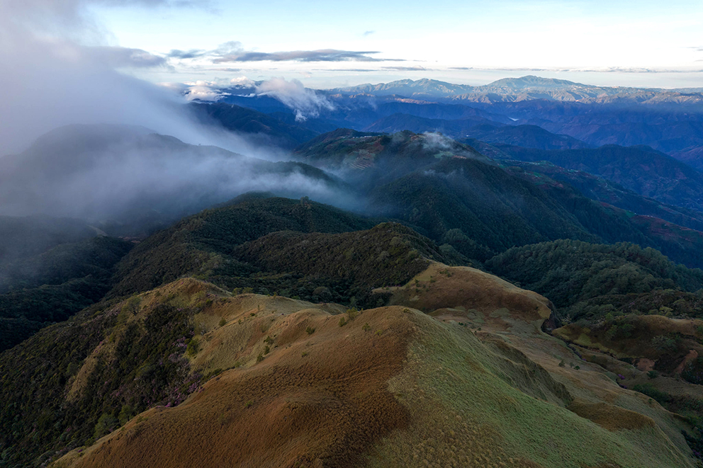
Mt. Pulag, Luzon’s highest peak at 2,922 meters above sea level, had already been inhabited before a presidential proclamation established it as an 11,550-hectare national park.
Sometime in 1992, Manuel’s family was one among the residents of Mt. Pulag who were farming some 2,000 hectares of the mountain on the Benguet portion to be awarded a Certificate of Land Ownership Award (CLOA) by the Department of Agrarian Reform.
However, the Department of Environment and Natural Resources (DENR) invalidated the CLOAs in 1998. Nevertheless, farmers like Manuel continued with their agricultural practices.
As did many farmers inside the protected area, Manuel gradually expanded by several hundred square meters over the years to meet their increasing family needs under threat of penalty and imprisonment as expansion was prohibited by the government .

Diminishing trees
From 1990 to 2020, human intervention such as agriculture decreased the forest covers of Mt. Pulag, according to a 2021 joint study by the Benguet State University – College of Forestry and the University of the Philippines Baguio – Department of Biology.
In 2020, around 80 percent of the national park remained forested and about 15 percent was converted for agricultural use. Additionally, structures covered some 178 hectares.
The steady decline in forest cover is not limited to Mt. Pulag alone but can be seen throughout Benguet Province where majority of the national park is situated.
Between 2001 to 2022, Benguet lost 2,820 has. of tree cover, according to Global Forest Watch (GFW), an online platform that provides data and tools for monitoring forests through cutting-edge technology.

This phenomenon of loss is much worse in Palawan, considered the Philippines’ “Last Frontier,” with 202,000 hectares of forest covers lost in that same period.
In the entire Philippines, a total of 1.42 million has. of tree cover was lost in that time period; the highest being in 2016 with 129,000 hectares of forest area lost .
2020 data from the Department of Environment and Natural Resources (DENR) provides that the Philippines has 7,226,394 hectares of forest cover, including mangroves. The number is half the estimated 14 million hectares of forest area in 1950.
Aside from agricultural activities, other factors identified as the main causes of this massive destruction of the country’s forest resources are illegal and indiscriminate logging practices, unfavorable policy environment, weak law enforcement, and slow pace of rehabilitation efforts.
However, in certain instances, it is the government which sanctions mass tree cutting. For example, the DENR Central Office in December 2018 issued to a private corporation a Special Tree Cutting Permit, allowing it to cut about 8,129 trees for a solar farm covering more than a thousand hectares of forest land in the boundary of Burgos and Bangui towns in the province of Ilocos Norte.
Ironically, most of the trees were planted under the then Asian Development Bank-backed Philippine Forestry Development Project which was implemented by the DENR.
Diminishing waters
In Mt. Pulag, the effect of diminishing forest cover is noticeable to residents near agricultural areas.
Creeks and springs have started to dry up, prompting many farmers to source water as far as two to three kilometers away, said Manuel.
Most noticeable is the decrease in the depth of the Eddet River, a major tributary of the mighty Agno River which feeds three of Luzon’s major dams – San Roque, Binga, and Ambuklao.
Agno River has the highest water discharge among rivers in the country, draining around 6.6 cubic kilometers of fresh water into Lingayen Gulf in Pangasinan.
“When we were children, the (Eddet) river was deeper than the height of an adult man. Now, it only happens during very strong typhoons or rainfall,” said Manuel.
The correlation between the decrease in water current and agricultural development has long been established in many studies, said Prof. Jason Leung, head of the Department of Environmental Sciences of the Benguet State University.
Also, upstream, midstream, and downstream factors can influence water currents.
For instance, changes in upstream conditions such as agricultural expansion, deforestation and land use development can contribute to changes in the water currents midstream and downstream, Leung added.
“Depending on conditions, even directional flows of rivers can shift as water currents become stronger or weaker. The shifting of river paths can result in eventual water current changes in other areas,” he said.
Natural phenomena, highly influenced by climate change, also contribute to changes in water currents. The amount, frequency, and duration of rainfall can directly amplify or decrease water current flows resulting in the overall water current along the river system, said Leung.
Trees affect turtles
According to the “Asset Accounts for Land” study released by the PSA in 2019, the Agno River is among the 13 principal river systems originating from the Cordillera, fueled by 46 major proclaimed forests and watersheds.
Changes in the integrity of these forests and watersheds absolutely affect the marine ecologies in the West Philippine Sea and the Pacific Ocean where these rivers drain to.
“The ecosystem services that forests provide, such as carbon sequestration, water filtration, and oxygen production, have robust impacts on marine ecology. If such services cannot be efficiently provided by the forests, then marine ecosystems can adversely be impacted,” warned Leung.
As a concrete example, when forests are not able to filter water efficiently due to decreased density of trees, this results in increased salinity, excess nutrients (from agricultural intensification), and acidity (acid rain) in the rivers that end up in marine ecosystems, he said.
Too much water acidity negatively impacts marine biological systems, while too much nutrients leads to excessive algal blooms causing oxygen levels to drop.
Hence, Leung said, conservation of forests is imperative if the integrity of marine ecology is to be preserved.
Additionally, renowned marine geologist, Prof. Fernando Siringan of the University of the Philippines Marine Science Institute, stated that changes in the natural flow of rivers have devastating effects on the integrity of coastal regions.
Siringan, who has extensively studied the coastal erosions in Ilocos Region, said changes in water current may change a river’s natural course and the natural environment along its banks, worsening erosions along the riverbanks and the delta.
Decrease in waters also affects the flow sediments which maintain the shores, he added.
Maintaining the integrity of the shorelines are critical in the conservation of the declining population of turtles, said Coastal Underwater Resource Management Actions (CURMA) coordinator, Carlos Tamayo.
The sandy coastline of La Union is a breeding site of marine turtles, a keystone species that annually return to their birthplace to lay eggs, said Tamayo.
Keystone species are those which other species in an ecosystem generally depend on; as such, their decline will result in drastic changes in the ecosystem.
Five of the seven sea turtle species in the world are found in the Philippines – the Green Turtle, Hawksbill Turtle, Loggerhead Turtle, Leatherback Turtle and Olive Ridley.
“The conservation of forests impacts ecosystems miles away as all ecosystems are interconnected in one way or another, either biophysically or geochemically, or both,” said Leung.
If forests are healthy, marine ecosystems will also be flourishing, he said.
The most ambitious reforestation
As a response to massive forest losses, the government launched in 2011 the biggest forest conservation project in Philippine history – the National Greening Program (NGP) – with the Department of Environment and Natural Resources (DENR) as the lead implementing agency.
The flagship program aimed to plant 1.50 billion trees in 1.50 million hectares of forestlands until 2016. In 2015, the NGP was expanded to cover all remaining unproductive, denuded, and degraded forestlands until 2028. This covers an additional 7.10 million hectares of forestlands – on top of the original 1.50 million-hectare target – to reforest.
The program has received at least ₱47.22 billion in allocation from 2011 to 2019 to implement the program.
Official DENR report stated that the initial NGP planted 1,369,762,802 seedlings in 1,662,229 hectares, exceeding its target by 111 percent.
Including the expanded NGP, DENR data claims 1,861,723,308 seedlings have been planted in 2,229,331 hectares of land.
However, in a December 2019 performance audit, the Commission on Audit (COA) noted that DENR “forced itself to meet the 1.50 million-hectare target.”
The audit stated that this hastened approach led to the imposition of “ambitious targets” on its field officers even though they “had been very vocal about not being able to handle the load.”
Additionally, the program proceeded without conducting proper surveys, mapping and planning, and it included far untenured areas without organizations to manage it.
“Instead of accelerating reforestation, fast-tracking only opened the program to waste,” the COA reported.
Government think-tank Philippine Institute for Development Studies also found that the survival rate of the trees planted under the NGP stood at 61 percent in 2016 or below the 85 percent goal.
Solutions
The best approach to environmental conservation is the holistic ridge-to-reef approach, according to Tamayo.
The ridge-to-reef proposes that addressing the environmental degradation in the uplands (ridge) helps address the coastal ecosystems problems and in protecting marine ecosystems (“reef”), and vice versa.
At the coasts, Siringan proposes the rehabilitation of coral reefs which, similar to mangroves, lessen the wave energy and protect the shoreline.
He said reefs with corals have lesser erosion rates, while adding more sediment to firm up seashores.
Aside from interventions on the physical and natural science domain, a socially-critical approach might just be the solution to environmental degradation, said Leung.
“We have an abundance of environmental programs that aim to increase forest areas, waste and pollution management, green architecture; however, not much attention is spotlighted on consumers,” he said.
The classic law of supply and demand is driving resource utilization, added the environment scientist. The increasing consumer demand is a parallel need for more natural resources.
“We should adopt new and more sustainable models of living and consuming,” Leung suggested. “Degrowth as driven by consumer consciousness should be the paradigm for ecological health as opposed to sustainable production which is driven by increasing demand.”
For indigenous people in Apayao, dubbed the “Last Frontier of the Cordillera,” the key to biodiversity conservation lies in trusting the wisdom of the indigenous peoples who have maintained their traditional knowledge systems, passed down from one generation to another.
Home to the critically endangered Philippine eagle, Apayao is listed as a “key biodiversity area” by the DENR.
“I guarantee that conservation programs of the government will work better if it involves the indigenous peoples,” said Isnag elder Ramos Bongui of Kabugao town.
Bongui said indigenous wisdom includes the preservation and maintenance of the forests because they sustain the rivers with waters, which in turn, sustain the communities with food and livelihood.
But the ultimate key to preserving environmental preservation is the passing on of the genuine value and concern towards the environment from one generation to another, he said.
*Manuel agreed to be interviewed but requested anonymity for fear of reprisal and threat to his family’s security.
*This report was made possible by Internews’ Earth Journalism Network’s Story Grants to support indigenous/minority journalists from Asia and Pacific Region.


